Scientists provide a chilling look at Antarctica’s future without ice
A groundbreaking map reveals Antarctica’s hidden geography, crucial for understanding ice dynamics and future sea-level rise.
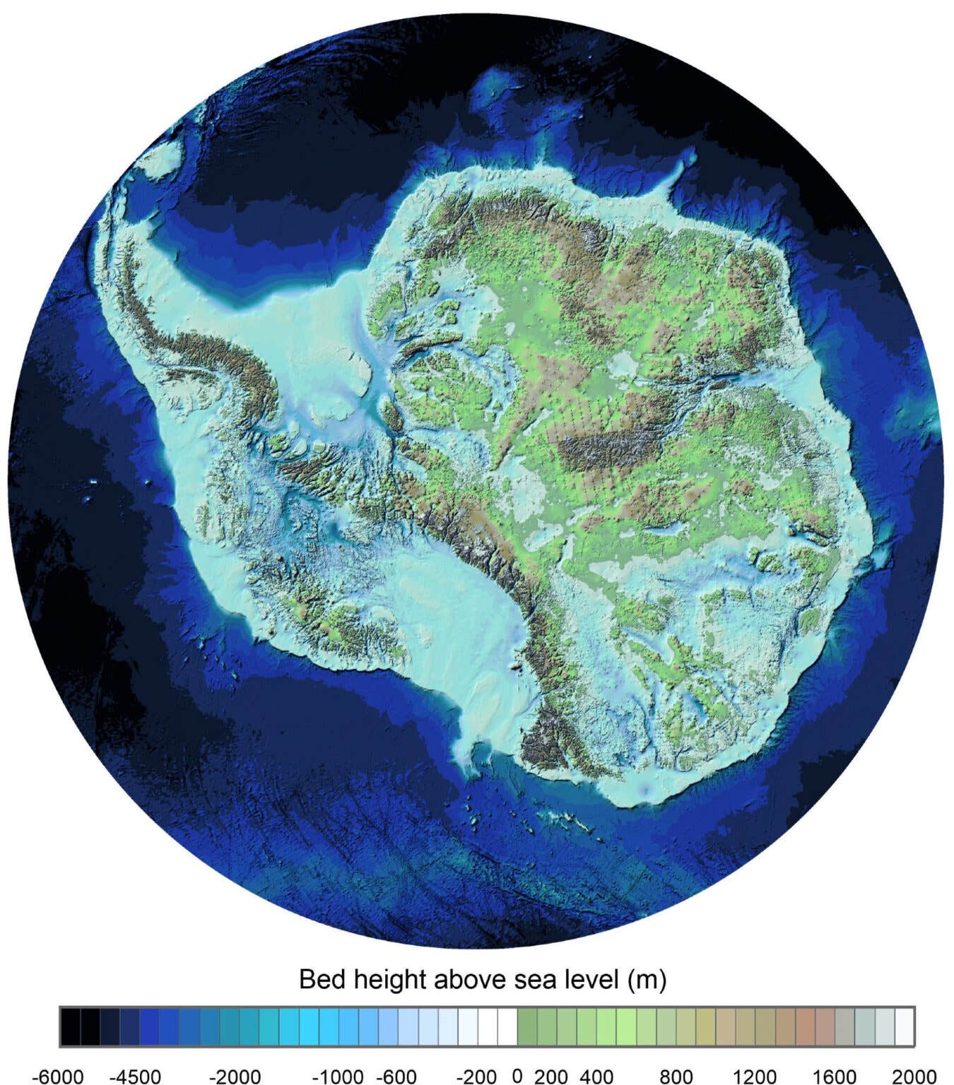
Bedmap3 reveals new insights into the topography of Antarctica. From Bedmap3 updated ice bed, surface and thickness gridded datasets for Antarctica. (CREDIT: Pritchard, H., et al.)
Underneath Antarctica’s endless sheets of ice lies a hidden world of deep valleys, towering peaks, and sprawling plains. For decades, scientists have attempted to chart this buried landscape, knowing it holds clues about Earth’s past and critical information about our planet's future. Now, researchers have released the most detailed map yet, named Bedmap3, revealing Antarctica’s secret terrain with remarkable clarity.
Led by the British Antarctic Survey (BAS), an international team compiled this latest map using data gathered from aircraft, satellites, ships, and even sleds pulled by dogs. Their findings, published in the journal Scientific Data, bring to light more than 82 million data points spanning six decades of exploration.
Dr. Hamish Pritchard, a glaciologist at BAS and lead author of the study, described the significance of this updated view:
“This is the fundamental information that underpins the computer models we use to investigate how the ice will flow across the continent as temperatures rise.”
He explains that Antarctica’s buried topography greatly influences how ice moves toward the ocean. “Imagine pouring syrup over a rock cake— all the lumps, all the bumps, will determine where the syrup goes and how fast. And so it is with Antarctica: some ridges will hold up the flowing ice; the hollows and smooth bits are where that ice could accelerate,” says Pritchard.
A Landscape Shaped by Ice and Time
Scientists have known for years that Antarctica was not always a frozen desert. Millions of years ago, it was lush and alive with plants and animals. Evidence of this past remains hidden beneath thick layers of ice. Understanding the landscape beneath the ice helps scientists reconstruct Antarctica’s geological history, revealing how continents have shifted and how climate has changed.
Previous maps, like Bedmap1 from 2001 and Bedmap2 from 2013, provided initial glimpses into this buried world. Yet, these maps had large gaps, especially in remote regions, leaving many unanswered questions. Bedmap3 closes many of these gaps, creating a detailed picture of what lies beneath, including deeper valleys and higher mountains than previously thought.
Related Stories
One significant revision in Bedmap3 involves identifying Antarctica’s thickest ice. Older maps located this spot in Adélie Land’s Astrolabe Basin. New data show the actual thickest point lies within an unnamed canyon in Wilkes Land, at coordinates 76.052°S, 118.378°E. Here, the ice reaches an incredible thickness of 4,757 meters (15,607 feet), taller than nearly every mountain in the continental United States.
Mapping Ice Thickness and Hidden Risks
Bedmap3 also improves scientists' ability to assess Antarctica’s ice volume and its potential effect on global sea levels. Antarctica holds 27.17 million cubic kilometers of ice, enough to raise sea levels by 58 meters if completely melted. Its vast ice sheets spread over 13.63 million square kilometers, averaging nearly two kilometers thick, slightly thicker than previous estimates.
These precise measurements matter greatly because Antarctica’s ice contributes significantly to rising seas. In fact, uncertainty about Antarctic ice loss remains one of the biggest unknowns in future climate predictions. Understanding exactly how much ice rests on rock versus floating on water helps researchers identify the most vulnerable areas of the ice sheet.
Peter Fretwell, a cartographer and co-author from BAS, highlights the new understanding Bedmap3 brings:
“In general, it's become clear the Antarctic Ice Sheet is thicker than we originally realised and has a larger volume of ice that is grounded on a rock bed sitting below sea-level.”
This discovery signals greater risk for ice melting where warm ocean water reaches beneath ice shelves, accelerating their breakup. Fretwell adds, “What Bedmap3 is showing us is that we have got a slightly more vulnerable Antarctica than we previously thought.”
Enhanced Tools for Climate Prediction
Bedmap3 achieves impressive accuracy by incorporating 84 new surveys since the last major map update. These surveys filled gaps across East Antarctica, including the previously unmapped South Pole region, Pensacola Basin, and Princess Elizabeth Land. Improvements also occurred along West Antarctica’s coasts, the Antarctic Peninsula, and throughout the Transantarctic Mountains.
On average, Bedmap3 has data points just 5.6 kilometers apart, twice as detailed as previous versions. Scientists used radar, gravity measurements, and seismic techniques to penetrate through kilometers of ice, accurately measuring thickness and mapping topography beneath. They carefully combined these data to avoid errors, ensuring consistency across areas where grounded ice meets floating ice shelves.
Antarctica’s Crucial Grounding Lines
A key innovation in Bedmap3 is the detailed mapping of grounding lines—where the ice sheet touches the ocean and starts floating. Grounding lines determine how rapidly ice melts or breaks apart, making them critical locations for climate change studies. Better understanding their exact positions allows scientists to predict which glaciers are most likely to retreat rapidly.
These insights are vital because Antarctica’s ice dynamics directly influence global sea levels. As ice grounded below sea level melts or moves faster toward the ocean, the resulting sea-level rise poses severe risks to coastal communities worldwide. Precise maps like Bedmap3 allow scientists to pinpoint vulnerable spots, giving communities valuable information for future planning.
A Window to Earth’s Geological Past
Beyond climate predictions, Bedmap3 gives researchers a rare chance to study Antarctica’s geological past. The hidden mountain ranges, river valleys, and flat basins provide clues about how Earth’s continents and climates evolved over millions of years. The new map is a window to a continent frozen in time, revealing landscapes formed long before ice dominated the region.
Each discovery adds more detail to Antarctica’s mysterious history. It also reminds scientists—and the public—of the continent’s broader role in shaping our planet’s future.
As Dr. Pritchard notes, understanding the hidden geography of Antarctica is no longer just about scientific curiosity:
“This data-driven approach will directly improve models that predict how Antarctica will change in the coming decades. Knowing what lies beneath allows us to anticipate how ice will respond to warming oceans.”
Bedmap3 has transformed how clearly we see the continent’s hidden face, providing scientists with a critical tool to track and understand the impacts of climate change.
Note: The article above provided above by The Brighter Side of News.
Like these kind of feel good stories? Get The Brighter Side of News' newsletter.
Joshua Shavit
Science & Technology Writer | AI and Robotics Reporter
Joshua Shavit is a Los Angeles-based science and technology writer with a passion for exploring the breakthroughs shaping the future. As a contributor to The Brighter Side of News, he focuses on positive and transformative advancements in AI, technology, physics, engineering, robotics and space science. Joshua is currently working towards a Bachelor of Science in Business Administration at the University of California, Berkeley. He combines his academic background with a talent for storytelling, making complex scientific discoveries engaging and accessible. His work highlights the innovators behind the ideas, bringing readers closer to the people driving progress.