Archeologists discover the oldest known map of the world
Explore the Imago Mundi, the oldest world map, revealing Babylonian views of geography, mythology, and the cosmos from 5th century BCE
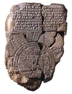
Dating back to the 5th century BCE, this clay tablet map was discovered in Sippar, a city in southern Iraq, located north of Babylon along the Euphrates River. (CREDIT: The British Museum, London)
The oldest surviving world map, known as the Imago Mundi, offers a fascinating glimpse into ancient Babylonian life. Dating back to the 5th century BCE, this clay tablet map was discovered in Sippar, a city in southern Iraq, located north of Babylon along the Euphrates River.
Though limited by the tools and knowledge of their time, the Babylonians managed to encapsulate their understanding of the world and heavens, representing their known environment in remarkable detail.
The Babylonian worldview placed their home city at the center of existence. This central placement of Babylon on the map mirrors the way other ancient cultures viewed their major cities, such as Athens or Jerusalem, as the focal point of life. Without modern technologies like satellites or accurate map-making tools, their perspective was naturally limited, reflecting a localized understanding of geography.
Surrounding Babylon, the map shows seven cities and seven islands encircled by two rings that represent water, described as a salt sea and a "bitter water" river. These bodies of water possibly signified boundaries known to the Babylonians. The cuneiform script inscribed at the top of the tablet identifies each location, giving the map a structured view of their known environment.
The map depicts notable places such as mountains, swamps, and cities like Urartu, Assyria, Der, and Elam, along with several unnamed cities. It even includes the southern marshes of modern Iraq and the Zagros Mountains, demonstrating the Babylonians’ effort to chart both natural and human-made landmarks.
The map’s cuneiform inscriptions reveal that it was a copy of an even older map, now lost to history. This insight adds an additional layer of depth, highlighting a continuity in their cartographic tradition.
Related Stories
The depiction on the reverse side of the tablet further emphasizes the blend between earthly and celestial elements in Babylonian culture. Familiar constellations are etched there, corresponding to parts of our modern zodiac. This connection between terrestrial and astronomical realms suggests a worldview that did not separate the earth from the heavens but saw them as interwoven parts of a grander cosmic design.
Interestingly, not all locations depicted on the map were real in a physical sense. The islands surrounding Babylon are believed to be mythical, representing the Babylonians’ ideas about the spiritual connections between the earth and the divine. These mythological places highlight how the Babylonians viewed their world not just through a physical lens but as a realm influenced by cosmic forces and divine beings.
Researchers today continue to uncover details about this ancient map. Known as the oldest surviving representation of the world, the Imago Mundi was created between 2,600 and 2,900 years ago. This tablet provides a unique window into Babylonian beliefs and practices, blending physical geography with mythology. It describes Mesopotamia, the "land between the rivers" of the Tigris and Euphrates, which was the heart of the known world for Babylonians.
In addition to geographical features, the map contains references to Marduk, the Babylonian god of creation, and mythical creatures such as Scorpio-man and Anzu, a lion-headed bird. These depictions illustrate how the Babylonians saw their world as influenced by gods and filled with mysterious creatures. The presence of such mythical figures reflects the cultural significance of storytelling in understanding natural and supernatural phenomena.
One of the more intriguing aspects of the Imago Mundi is the double-ringed boundary labeled as the "Bitter River." This ring symbolized the limits of the known world, with Mesopotamia enclosed within. This representation emphasized the Babylonian belief in their homeland as the world's center, a place where the physical, spiritual, and mythical realms intertwined.
The British Museum, which acquired the map in 1882, has been instrumental in deciphering the tablet, helping to fill in gaps about Babylonian cosmology. Expert Dr. Irving Finkel, in a video released by the museum, explained the significance of the Imago Mundi, pointing out that it offered much more than just a geographical guide.
"You have encapsulated in this circular diagram, the whole of the known world in which people lived, flourished, and died," Finkel noted. He further explained that the map also pushed beyond the boundaries of reality into the realm of imagination—a key element in understanding ancient Babylonian culture.
The map even hints at a monumental structure, with references to "The Great Wall" found alongside one of the diagonals of the map. According to Finkel, the height of this wall was recorded as 840 cubits, with trees reaching up to 120 cubits.
Although the identity of the scribe who crafted this map remains partially lost, the father's name survives, giving a small personal connection to the ancient creator. The fact that this map was a replica of an older, even more ancient map only deepens its historical value, showing the enduring nature of Babylonian exploration and curiosity.
The Imago Mundi not only offers insights into the geography and mythology of the time but also highlights the Babylonians' advanced knowledge of astronomy. They were among the first civilizations to connect their terrestrial surroundings with the heavenly bodies above, suggesting an intricate understanding of their environment.
The reverse side of the tablet, with its depiction of recognizable zodiac constellations, indicates that they observed the skies with a level of sophistication that has influenced later astronomical traditions.
Researchers’ decoding efforts have revealed more about how Babylonians conceptualized their place in the universe. The double ring surrounding Mesopotamia, for example, is seen as a symbolic representation of boundaries, underscoring their belief in Mesopotamia as the center of existence.
The mythical elements, the mention of deities, and the constellations all point to an ancient civilization deeply engaged with both the physical and metaphysical aspects of their world.
The Imago Mundi is more than just a historical artifact; it is a testament to human curiosity and the desire to understand the world and cosmos. It merges the practical with the mystical, offering a layered understanding of life as seen by the Babylonians.
This blend of mythology, geography, and astronomy encapsulated in a single clay tablet speaks to the profound cultural and intellectual achievements of one of the world’s earliest civilizations.
Note: Materials provided above by The Brighter Side of News. Content may be edited for style and length.
Like these kind of feel good stories? Get The Brighter Side of News' newsletter.
Joshua Shavit
Science & Technology Writer | AI and Robotics Reporter
Joshua Shavit is a Los Angeles-based science and technology writer with a passion for exploring the breakthroughs shaping the future. As a contributor to The Brighter Side of News, he focuses on positive and transformative advancements in AI, technology, physics, engineering, robotics and space science. Joshua is currently working towards a Bachelor of Science in Business Administration at the University of California, Berkeley. He combines his academic background with a talent for storytelling, making complex scientific discoveries engaging and accessible. His work highlights the innovators behind the ideas, bringing readers closer to the people driving progress.